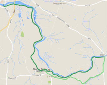
Description One of my favourite walks follows the River Teifi from the bridge at Llechryd, down through Cilgerran and the Welsh Wildlife Centre and into Cardigan arriving via Cardigan old bridge. Along the way there are wild flowers, two castles, chance to see herons, otters and water buffalo [depending on time of year].
Start The walk starts at the bridge in Llechryd, if you are driving you can park at the wide part of the road to Monordeifi and return to your car either by foot or by bus. Grid Ref reference SN 175 460
Refreshments are available from the shop in Cilgerran or at the Welsh Wildlife Centre and there are lots of options in Cardigan.
- The path begins between the river and the gate house and follows the river Teifi past salmon traps, an old quarry and abandoned ferry point cottage to reach Cilgerran coracle information centre [with toilets] after a beautiful riverside walk
- Continue past the picnic tables for about 50 metres and look out for a path up the side of the hill. A short climb brings you out below Cilgerran castle. Here the path loops around the castle and you pass in front of a cottage bearing right along a narrow track which leads to the NT castle entrance round to your right.
- Turn left away from the castle and then right onto a small road which shortly bends round to the left giving a view of the church in the distance.
- Within 200 metres, look out for a footpath down to your right and follow it down to cross a stream via a small bridge. The path skirts in front of and around a small group of cottages, bringing you out on a lane where you turn left.
- Within 200 metres, turn right through a ‘kissing gate’ and follow the path along the edge of the field with the old hedge bank on your right to the next ‘kissing gate’ which leads into woodland high above the river.
- The path curves round to the left to cross a small bridge before skirting high above the river, with quite dramatic views down through the trees into Cilgerran gorge below.
- The path narrows and in spring and early summer is bordered by wild flowers, particularly the bluebells are a delight on this stretch. The path passes a badgers set on the left before climbing to a gate where you have a choice of routes.
- a – the gorge walk – turn right, pass through a gate and after about 300 metres take the path signposted to your right and enter the Welsh Wildlife Centre where the gorge walk, though steep in places is well signposted b – the more direct walk – carry straight on across the top of a field [private gate to left] and drop down onto a lovely path which skirts fields to bring you out at the Welsh Wildlife Centre
- From the wildlife centre car park, pass through the large gate and follow the old Cardigan Railway track with the River Teifi on your right and the marshes on your left to Cardigan. To return to your car from Cardigan, the 460 Carmarthen bus run by Richard Brothers leaves from Finch Square passing through Llechryd.
- Circular walk – from the car park, turn right and follow the track to Cilgerran village. Turn left to take the first small road into the village which drops down before passing the church. On seeing the sign for Cilgerran castle, retrace your steps from 3, or enter the village and follow the road via Garnons mill to Llechryd bridge.
Accommodation
- Felin Geri Luxury Safari Tents
- Trenewydd Farm Holiday Cottages
- Penwern Fach Holiday Cottages Cenarth
- Quay Street Studios Cardigan
- Poppit Sands Caravan Park
- Dechrau Newydd Ferwig nr Cardigan
- The Cwtch Cilgerran
- Maenayron Holiday Home Cardigan
- Morfa Isaf Farm Guesthouse Llangrannog
- Morfa Isaf Farm Cottages Llangrannog
- Troedyrhiw Five Star Holiday Cottages Cardigan
- Mwnt Holiday Cottages Cardigan


